|
|
|
|
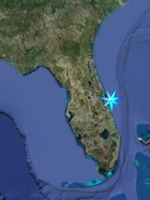
Fishing Merritt
Island National Wildlife Refuge and
Canaveral National Seashore
|
|
|
|
 Together
the
Merritt Island National Wildlife Refuge
and the
Canaveral National Seashore provide many
square miles of some of the finest
Backcountry saltwater fishing for Redfish,
Seatrout, Snook and Tarpon available in the
state. (Click map to see larger
version) The Mosquito Lagoon in
particular has wide expanses of some of the
most pristine grass flats in the state.
However there are also canals, impoundments,
mangrove shorelines salt marshes creeks and
even some freshwater barrow pits that offer
great fishing on the refuge by foot, boat,
and paddling. If fishing by canoe or kayak
please keep a sharp eye on the weather and
wind conditions. The Indian River and
Mosquito Lagoon are both wide expanses of
water and unexpected or unplanned for
weather conditions can place you in danger.
Before you fish the refuge, please note the
permit requirement just below. Together
the
Merritt Island National Wildlife Refuge
and the
Canaveral National Seashore provide many
square miles of some of the finest
Backcountry saltwater fishing for Redfish,
Seatrout, Snook and Tarpon available in the
state. (Click map to see larger
version) The Mosquito Lagoon in
particular has wide expanses of some of the
most pristine grass flats in the state.
However there are also canals, impoundments,
mangrove shorelines salt marshes creeks and
even some freshwater barrow pits that offer
great fishing on the refuge by foot, boat,
and paddling. If fishing by canoe or kayak
please keep a sharp eye on the weather and
wind conditions. The Indian River and
Mosquito Lagoon are both wide expanses of
water and unexpected or unplanned for
weather conditions can place you in danger.
Before you fish the refuge, please note the
permit requirement just below.
|
NOTE;
Free Fishing Permit Required!
|
|
Beginning February 1, 2009 any person
fishing on Merritt Island National Wildlife
Refuge without a signed FREE refuge fishing
permit will be cited. The fine for
violating the permit requirement is $125.00.
The permit is required for ALL fishermen -
those fishing from land and those fishing
from a vessel in refuge waters. You can
pick up a permit at two information kiosks
located at either entrance to the refuge or
you can download it from the link above.
Once you have your fishing permit, read it,
sign the business card sized permit and keep
it in your wallet. The primary purpose of
the permit is to ensure that all fishermen
and women are aware of the fishing
regulations that apply to the refuge. The
page you download will have a fishing map,
refuge specific regulations and two permits.
|
|
Boat Ramps
|
|
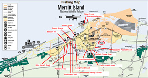
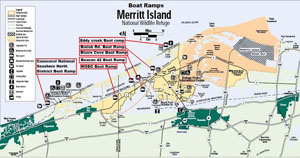 There
are a total of six boat ramp areas within
Merritt Island National Wildlife Refuge and
Canaveral National Seashore. (Click
map to see larger version) Five of
them are on the Mosquito Lagoon and the
fifth is at Blairs Cove off of Haulover
Canal. All except the Canaveral Seashore
North District boat ramp are easily accessed
from the Titusville Entrance to the refuge. There
are a total of six boat ramp areas within
Merritt Island National Wildlife Refuge and
Canaveral National Seashore. (Click
map to see larger version) Five of
them are on the Mosquito Lagoon and the
fifth is at Blairs Cove off of Haulover
Canal. All except the Canaveral Seashore
North District boat ramp are easily accessed
from the Titusville Entrance to the refuge.
|
|
Boat Ramps List;
Eddy Creek
(Canaveral South District)
GPS N 28 40.541 W 80 38.884
Google Satellite Image
Biolab Road
GPS N 28 42.362 W 80 43.229
Google Satellite Image
Blairs Cove / Haulover Canal
GPS N 28 43.980 W 80 45.421
Google Satellite Image
Beacon 42 Boat Ramp
GPS N 28 45.369 W 80 45.963
Google Satellite Image
WSEG Boat Ramp
GPS N 28 47.394 W 80 47.260
Google Satellite Image
North District Boat Ramp
(Canaveral North District)
GPS N 28 56.075 W 80 49.750
Google Satellite
Image
|
|
KAYAK FISHING THE REFUGE;
|
|
One of my favorite ways to
fish the lagoon is by canoe or kayak. There
are four designated canoe launches out on
the refuge and seashore property. Three of
them are on the Mosquito Lagoon, Beacon Road
Boat Ramp, Biolab Road Boat Ramp, and Eddy
Creek Boat Ramp. A forth exists at Dummitt
Cove and provides access to the Indian River
Lagoon. The cove itself can be very good
fishing.
Click here for more information.However,
the general rule about paddling the refuge
is this. You can not launch from Black Point
Wildlife Drive or any road connected to it
except Long Pond Road. You can not launch or
paddle inside the mosquito impoundments.
Other than that, if it is open to the public
and you can get your boat to it you can
launch from it. This includes any dike road
open to traffic, or if you should be so
inclined to outfit a mountain bike to tow a
kayak, any of the roads listed below. Some
good areas are Pucket Creek off Pumphouse
road where you will have to carry the boat
about 50 feet to the water, West Gator Creek
Road, Catfish Creek Loop, Peacocks Pocket
Loop, Biolab Road, the Guard Shack Road, the
northeast corner of Haulover Canal, and the
Patillo Creek Area of Shiloh Road (see "The
Dike Roads" just below for graphics).
|
|
THE DIKE ROADS and other shoreline
locations;
|
|
There are many miles of dike roads on the
refuge and some of them are open to visitor
traffic, while others have been closed off
to motor vehicles. The refuge occasionally
decides to close certain dike roads to motor
traffic for several reasons, deteriorating
road conditions, The presence of certain
species of birds during migratory periods,
or problems with littering or other issues.
However, unless otherwise specifically
posted as no entrance beyond this point,
barricaded roads are still open to foot and
bicycle traffic. For those who are willing
to pack their tackle on their person or
mountain bike, it is possible to find
excellent fishing opportunities that have
not been disturbed by recent activity.
|
|
 The
Pumphouse Road loop is a quick drive
from Titusville only about a half mile into
the refuge and will be the first left turn
after the entrance. Formerly you could drive
the entire loop with your car but it has
since been closed off to all but foot and
bicycle unse.to Trout can be had from the
roadside canal just past the open cove up to
the pumphouse. I've used live shrimp,
plastic baits and the original Rapala balsa
minnow with decent results with the latter
being my favorite. Up past the pumphouse
used to pump water from one side of a refuge
access road to the other, I've jumped an
occasional small tarpon, seen plenty of
others rolling but not hitting, and caught
trout on rapalas and live shrimp. The
roadside canal that extends Northeast from
the pumphouse seems to be pretty shallow and
is very brushy on both sides. You can also
hike or bike the dike path that extends from
the pumphouse itself to the lagoon where
there is a possibility of enticing early
morning topwater action for seatrout or
redfish. or along the opposite side of
Puckett Creek from where you park. The
Pumphouse Road loop is a quick drive
from Titusville only about a half mile into
the refuge and will be the first left turn
after the entrance. Formerly you could drive
the entire loop with your car but it has
since been closed off to all but foot and
bicycle unse.to Trout can be had from the
roadside canal just past the open cove up to
the pumphouse. I've used live shrimp,
plastic baits and the original Rapala balsa
minnow with decent results with the latter
being my favorite. Up past the pumphouse
used to pump water from one side of a refuge
access road to the other, I've jumped an
occasional small tarpon, seen plenty of
others rolling but not hitting, and caught
trout on rapalas and live shrimp. The
roadside canal that extends Northeast from
the pumphouse seems to be pretty shallow and
is very brushy on both sides. You can also
hike or bike the dike path that extends from
the pumphouse itself to the lagoon where
there is a possibility of enticing early
morning topwater action for seatrout or
redfish. or along the opposite side of
Puckett Creek from where you park.
GPS N 28 38.274 W 80 46.714
Google Satellite Image
|
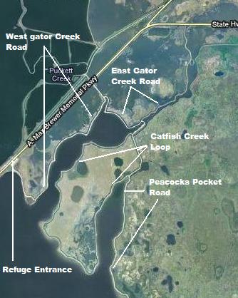 The
Creek Roads; Gator Creek and
Catfish Creek;There are essentially
three sections here that connect to each
other starting right at the entrance to
the refuge from Titusville. The first
section is commonly referred to as West
Gator Creek Road and can be accessed
from the west end of the Max Brewer
Causeway at the entrance to the refuge
and just outside of Titusville City
Limits. You will see a small paved
parking lot with an informational kiosk
and the entrance to the road at the west
end of the parking lot. There are some
dips in the road but with care it should
be no problem for an auto. The first leg
along the lagoon is very shallow for
fishing from the shore. You would have
to be able to cast a pretty good
distance. However, a canoe or kayak can
be launched here and decent flats
fishing can be accessed just offshore.
After the road turns to the left, it
runs along gator creek for about a mile
and the water is deep enough to fish
from shore. As the road turns back
towards Max Brewer Parkway you will see
a connection to East Gator Creek Road. The
Creek Roads; Gator Creek and
Catfish Creek;There are essentially
three sections here that connect to each
other starting right at the entrance to
the refuge from Titusville. The first
section is commonly referred to as West
Gator Creek Road and can be accessed
from the west end of the Max Brewer
Causeway at the entrance to the refuge
and just outside of Titusville City
Limits. You will see a small paved
parking lot with an informational kiosk
and the entrance to the road at the west
end of the parking lot. There are some
dips in the road but with care it should
be no problem for an auto. The first leg
along the lagoon is very shallow for
fishing from the shore. You would have
to be able to cast a pretty good
distance. However, a canoe or kayak can
be launched here and decent flats
fishing can be accessed just offshore.
After the road turns to the left, it
runs along gator creek for about a mile
and the water is deep enough to fish
from shore. As the road turns back
towards Max Brewer Parkway you will see
a connection to East Gator Creek Road.
GPS West Entrance N 28 37.666 W
80 47.229
Google Satellite Image West Entrance
GPS East Entrance N 28 38.195 W 80
46.639
Google Satellite Image East Entrance
Catfish Creek Loop; To get to
Catfish Creek Loop Road, it is best to
take SR 406 to the second entrance of
East Gator Creek Road and turn left.
Follow this road and take the first left
onto Gator Creek Road. This will turn
south then abrubtly turn southeast for
about .3 miles followed by a turn to the
northeast after which you will see a
right hand turnoff. Take this and it
will almost immediately turn you to the
southwest and to the entrance of Catfish
Creek Loop. By staying to the right, The
first section allows you to fish the
oposite bank of Gator Creek until it
reaches the Indian River Lagoon. Then
there is a small section along the
lagoon with decent flats fishing until
you get to Catfish Creek. The road then
turns to the north at the mouth of
Catfish creek until the creek runs out.
The end of the loop as well as the
intersection for Peacocks Pocket road
(to the right) are just ahead.
GPS N 28 37.941 W 80 46.305
Google Satellite Image
|
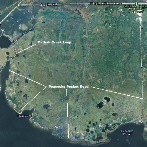 Peacocks
Pocket; There are two ways to get to
Peacocks Pocket. One is to take the
eastern leg of the Catfish Creek Loop
and then take the first left which will
take you along the eastern shore of
catfish creek to the lagoon then turn
southwest along the lagoon, around a
smaller cove and then around Peacocks
Pocket right before turning due North to
take you straight to SR 402. The other
way is of course to take 406 to 402
until you pass the Refuge Visitors
Center. After passing the center, look
for Peacocks Pocket Road on the right
and drive due south until you get to the
"Buzzards Roost" an old radar tower. Due
not park too close to the water here as
it is easy to get hopelessly stuck.
launching a canoe or kayak puts you on
some very good flats for reds and
seatrout. Paddling North, you'll come to
the mouth of Banana Creek. This is
Kennedy Space Center property and entry
is prohibited into the creek. Do not
think you can slip in for a quick
paddle. Trust me, they see you, and you
are on camera. There is however a trough
or channel leading into the creek and
during the cooler months this channel
produces fish while the flats will
become alive with fish as the weather
warms. Peacocks
Pocket; There are two ways to get to
Peacocks Pocket. One is to take the
eastern leg of the Catfish Creek Loop
and then take the first left which will
take you along the eastern shore of
catfish creek to the lagoon then turn
southwest along the lagoon, around a
smaller cove and then around Peacocks
Pocket right before turning due North to
take you straight to SR 402. The other
way is of course to take 406 to 402
until you pass the Refuge Visitors
Center. After passing the center, look
for Peacocks Pocket Road on the right
and drive due south until you get to the
"Buzzards Roost" an old radar tower. Due
not park too close to the water here as
it is easy to get hopelessly stuck.
launching a canoe or kayak puts you on
some very good flats for reds and
seatrout. Paddling North, you'll come to
the mouth of Banana Creek. This is
Kennedy Space Center property and entry
is prohibited into the creek. Do not
think you can slip in for a quick
paddle. Trust me, they see you, and you
are on camera. There is however a trough
or channel leading into the creek and
during the cooler months this channel
produces fish while the flats will
become alive with fish as the weather
warms.
GPS N 28 37.549 W 80 46.418
Google Satellite Image
|
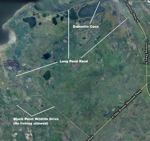 Long
Pond Road; As of this writing Long
Pond Road is closed to motor vehicle
traffic due to hurricane damage and a
lack of funding to fix it. However it is
still open to foot and bike traffic.
Long Pond Road provides about 5 miles of
fishing access, with several good
canoe/kayak launch sites along its run
where the road is wide enough to park
and a decent launch beach present. Long
Pond Road can be accessed from two
points. The closest to Titusville is off
of Black Point Wildlife Drive near the
end of the drive. The second entrance is
about 3 miles or so north of the
intersection of SR 406 and SR 3.
Remember though that by going to the
Black Point entrance you have to drive
through about 4 1/2 miles of Black Point
itself, before you can even think about
fishing (No fishing or boat launching
allowed off of Black Point). In addition
you have to understand that Black Point
is a world reknowned birdwatching site,
complete with birdwatchers from all over
globe who like to stop and watch birds
while at the same pumping more dollars
into our local economy than most people
realize. If fishing is the purpose of
your visit, the SR-3 entrance is the
better choice and will get you fishing
faster as it quickly skirts the southern
shoreline of Dummit Cove. This can be a
great fishing spot from the dike itself
for trout and reds. In fact some very
big reds have come from the cove,
usually from boats but anything is
possible. After it passes the mouth of
the cove it runs along the Indian River
Lagoon. These are waters more suitable
for wading or canoe/kayak fishing than
shore fishing as it is very shallow
along the dike. However it does seem to
be easily waded with a firm sandy bottom
and nice grass flats. Do the stingray
shuffle (see "The Dike Roads" above on
this page) and start fishing in about
knee depth or slightly less water, which
isn't very far offshore. The road then
turns south runs along a channel that
enters a cove. You can fish from shore
along the cove. The road then quickly
makes the connection to Black Point
where you can turn left and join the
birdwatchers making their exit. Be
careful entering Black Point as there is
a blind turn right before the birders
reach the intersection and they may not
see you entering. Long
Pond Road; As of this writing Long
Pond Road is closed to motor vehicle
traffic due to hurricane damage and a
lack of funding to fix it. However it is
still open to foot and bike traffic.
Long Pond Road provides about 5 miles of
fishing access, with several good
canoe/kayak launch sites along its run
where the road is wide enough to park
and a decent launch beach present. Long
Pond Road can be accessed from two
points. The closest to Titusville is off
of Black Point Wildlife Drive near the
end of the drive. The second entrance is
about 3 miles or so north of the
intersection of SR 406 and SR 3.
Remember though that by going to the
Black Point entrance you have to drive
through about 4 1/2 miles of Black Point
itself, before you can even think about
fishing (No fishing or boat launching
allowed off of Black Point). In addition
you have to understand that Black Point
is a world reknowned birdwatching site,
complete with birdwatchers from all over
globe who like to stop and watch birds
while at the same pumping more dollars
into our local economy than most people
realize. If fishing is the purpose of
your visit, the SR-3 entrance is the
better choice and will get you fishing
faster as it quickly skirts the southern
shoreline of Dummit Cove. This can be a
great fishing spot from the dike itself
for trout and reds. In fact some very
big reds have come from the cove,
usually from boats but anything is
possible. After it passes the mouth of
the cove it runs along the Indian River
Lagoon. These are waters more suitable
for wading or canoe/kayak fishing than
shore fishing as it is very shallow
along the dike. However it does seem to
be easily waded with a firm sandy bottom
and nice grass flats. Do the stingray
shuffle (see "The Dike Roads" above on
this page) and start fishing in about
knee depth or slightly less water, which
isn't very far offshore. The road then
turns south runs along a channel that
enters a cove. You can fish from shore
along the cove. The road then quickly
makes the connection to Black Point
where you can turn left and join the
birdwatchers making their exit. Be
careful entering Black Point as there is
a blind turn right before the birders
reach the intersection and they may not
see you entering.
GPS N 28 42.187 W 80 43.554
Google Satellite Image
|
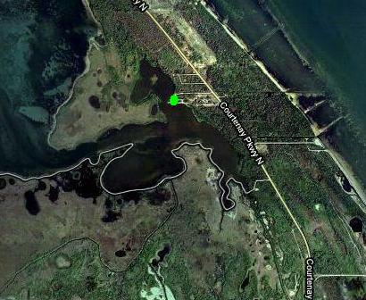 Dummit
Cove; About four miles north of the
intersection of SR-406 and SR-3 on the
left (west) you will see a sign for the
Sendler Education Outpost and the
entrance to Dummit Cove. There are
several spots for shore fishing here but
this is a great place to launch a canoe
or kayak in to paddle and fish as the
seagrass beds are quite lush in places
and there are some red mangroves to fish
as well. I have fished here a few times
and have had success with trout but I
also know some big redfish in the 40+
inch range have been caught here. The
deeper channel leading out the mouth may
be worth a try in cooler weather periods
with jigs and plastics. Dummit
Cove; About four miles north of the
intersection of SR-406 and SR-3 on the
left (west) you will see a sign for the
Sendler Education Outpost and the
entrance to Dummit Cove. There are
several spots for shore fishing here but
this is a great place to launch a canoe
or kayak in to paddle and fish as the
seagrass beds are quite lush in places
and there are some red mangroves to fish
as well. I have fished here a few times
and have had success with trout but I
also know some big redfish in the 40+
inch range have been caught here. The
deeper channel leading out the mouth may
be worth a try in cooler weather periods
with jigs and plastics.
GPS N 28 42.589 W 80 44.090
Google Satellite Image
|
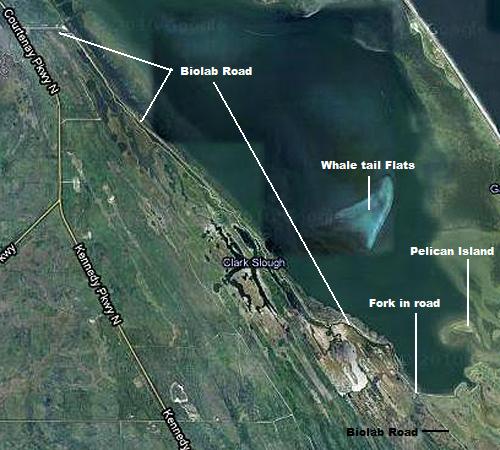 Biolab
Road; About two miles north of the
intersection of SR-406 and SR-3 you will
see a building marked as NASA's
Atmospheric Sciences Laboratory. The
dirt road beginning here is called
Biolab Road and runs down to the
Mosquito Lagoon where there exists a
boat ramp and parking area. It then runs
along the lagoon south until it reaches
the Playalinda Beach access road. Right
before you get to the boat ramp parking
are you will see a canal. This may be
the orginal Haulover Canal that predates
the present day one farther north. If
canoe/kayak fishing, put in here at the
canal and paddle out the mouth of the
canal east into the mosquito lagoon.
Turn to the left and follow the
shoreline until you come to a small
island and fish the flats around the
island. I've had some great days here
for redfish. You might also try the
canal itself in the spring and summer
for snook and tarpon. Farther south on
Biolab Road it passes the whale tail
flats. These flats are about a mile
offshore and hold a unique population of
very large redfish. These fish are
regularly hammered by professional
guides and are very wary. If you fish
bait for these fish please use circle
hooks to help ensure a successful
release. Farther South, towards the end
of the lagoon you will see Pelican
Island offshore. There is a deeper area
on the west side of the island that
holds redfish and seatrout in the cooler
months and even reportedly some large
Tarpon in the early spring. Biolab
Road; About two miles north of the
intersection of SR-406 and SR-3 you will
see a building marked as NASA's
Atmospheric Sciences Laboratory. The
dirt road beginning here is called
Biolab Road and runs down to the
Mosquito Lagoon where there exists a
boat ramp and parking area. It then runs
along the lagoon south until it reaches
the Playalinda Beach access road. Right
before you get to the boat ramp parking
are you will see a canal. This may be
the orginal Haulover Canal that predates
the present day one farther north. If
canoe/kayak fishing, put in here at the
canal and paddle out the mouth of the
canal east into the mosquito lagoon.
Turn to the left and follow the
shoreline until you come to a small
island and fish the flats around the
island. I've had some great days here
for redfish. You might also try the
canal itself in the spring and summer
for snook and tarpon. Farther south on
Biolab Road it passes the whale tail
flats. These flats are about a mile
offshore and hold a unique population of
very large redfish. These fish are
regularly hammered by professional
guides and are very wary. If you fish
bait for these fish please use circle
hooks to help ensure a successful
release. Farther South, towards the end
of the lagoon you will see Pelican
Island offshore. There is a deeper area
on the west side of the island that
holds redfish and seatrout in the cooler
months and even reportedly some large
Tarpon in the early spring.
GPS N 28 42.368 W 80 43.315
Google Satellite Image
|
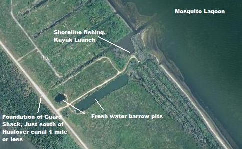 Guard
Shack; I call this place the Guard
Shack because there used to be a Space
Center Security Guard Shack that I used
as a reference to find the road. If it
has an official name, I don't know it.
The guard shack road is no longer there
but the concrete foundation remanains
and can be seen about a mile south of
Haulover Canal. As of this writing I
have fished the place once, with live
shrimp under a cork and I did catch
several redfish, and I have heard from
another source that small tarpon can be
hooked in the creeks or canals south of
the cove. I have yet to explore the
immediate area by canoe but based on
this aerial photo it certainly looks
interesting. There seems to be a deeper
channel right along the shorline north
of the opening to the canal with the
cove that leads to several other canals
running parallel to each other. If these
canals have any depth to them they could
hold small tarpon as I have found tarpon
in similar situations elsewhere. Guard
Shack; I call this place the Guard
Shack because there used to be a Space
Center Security Guard Shack that I used
as a reference to find the road. If it
has an official name, I don't know it.
The guard shack road is no longer there
but the concrete foundation remanains
and can be seen about a mile south of
Haulover Canal. As of this writing I
have fished the place once, with live
shrimp under a cork and I did catch
several redfish, and I have heard from
another source that small tarpon can be
hooked in the creeks or canals south of
the cove. I have yet to explore the
immediate area by canoe but based on
this aerial photo it certainly looks
interesting. There seems to be a deeper
channel right along the shorline north
of the opening to the canal with the
cove that leads to several other canals
running parallel to each other. If these
canals have any depth to them they could
hold small tarpon as I have found tarpon
in similar situations elsewhere.
GPS N 28 43.524 W 80 44.704
Google Satellite Image
|
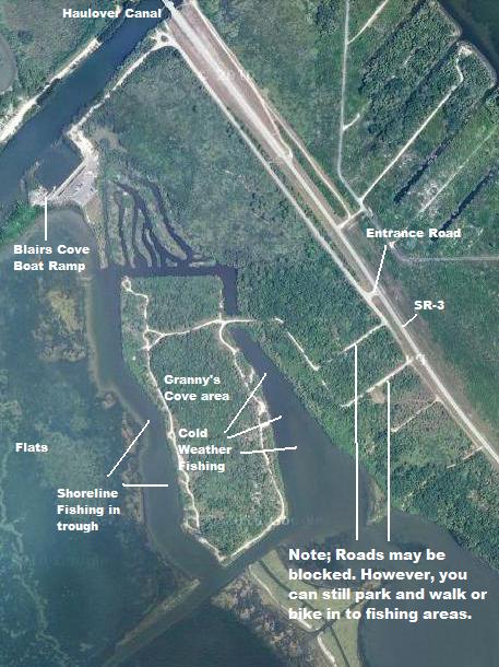 Granny's
Cove; I'm not sure where the name
Granny's Cove comes from or even if it's
the real name of this place but this can
be a pretty good place to fish. It is
immediately south of Haulover Canal.
Look for the entrance shortly after you
pass the Guard Shack mentioned just
above. You used to be able to drive out
onto the island but it has recently been
barracaded off to vehicles. However, it
is still legal to park near the
barracades and either hike or bike into
the area and the fishing here can be
pretty good for seatrout after cold
weather has set into the area. As the
image at left shows this is an island
carved out of the natural shoreline with
canals on three sides and the lagoon on
the other. I've caught trout in the
canal opposite the river and in the
river from shore at this location. Fish
the canal in the cooler months by
finding an open spot in the shoreline
trees. Don't cast straight out but at an
angle to work your bait or lure about 8
to 10 feet offshore of the trees. I
usually do this with a live shrimp 18 to
24 inches below a cork but I have used
jigs, spoons and other lures in similar
situations with good results. In the
warmer months try the riverside. Here
there is a trough or area of deeper
water running along the shoreline, then
shallow flats farther offshore. Work
baits and lures close to the flats in
the trough. Granny's
Cove; I'm not sure where the name
Granny's Cove comes from or even if it's
the real name of this place but this can
be a pretty good place to fish. It is
immediately south of Haulover Canal.
Look for the entrance shortly after you
pass the Guard Shack mentioned just
above. You used to be able to drive out
onto the island but it has recently been
barracaded off to vehicles. However, it
is still legal to park near the
barracades and either hike or bike into
the area and the fishing here can be
pretty good for seatrout after cold
weather has set into the area. As the
image at left shows this is an island
carved out of the natural shoreline with
canals on three sides and the lagoon on
the other. I've caught trout in the
canal opposite the river and in the
river from shore at this location. Fish
the canal in the cooler months by
finding an open spot in the shoreline
trees. Don't cast straight out but at an
angle to work your bait or lure about 8
to 10 feet offshore of the trees. I
usually do this with a live shrimp 18 to
24 inches below a cork but I have used
jigs, spoons and other lures in similar
situations with good results. In the
warmer months try the riverside. Here
there is a trough or area of deeper
water running along the shoreline, then
shallow flats farther offshore. Work
baits and lures close to the flats in
the trough.
GPS N 28 43.830 W 80 45.052
Google Satellite Image
|
 Haulover
Canal; Haulover Canal is the only
connection between the Indian River
Lagoon to the West and the Mosquito
Lagoon to the East and is one of the
area's most popular fishing spots
especially for those fishing without the
benefit of a boat. It is deeper than
about 90% of the lagoon and lined with
rocks overshadowed by trees along the
shoreline, which provide cover and
structure for many species. There are
some large redfish in the canal as well
as Seatrout, Black Drum, Mangrove or
Grey Snapper, Sheepshead, Jack crevale,
Bluefish, and the occasional Snook and
Tarpon. Fish along or just off the rocks
or cast into the channel itself. I
usually either freeline a shrimp along
the rocks or if fishing the channel, out
a split shot or small sinker 18 inches
above the hook to get the bait deeper
into the channel. Near the ends of the
canal can be especially good places to
channel fish and Haulover is one a those
places where you never know quite what
will hit next. If canoe or kayak fishing
drift with the current and work the
shoreline, being careful to respect
those fishing the shoreline, (they don't
have the options you do) and be careful
of the boats passing through. Haulover
Canal; Haulover Canal is the only
connection between the Indian River
Lagoon to the West and the Mosquito
Lagoon to the East and is one of the
area's most popular fishing spots
especially for those fishing without the
benefit of a boat. It is deeper than
about 90% of the lagoon and lined with
rocks overshadowed by trees along the
shoreline, which provide cover and
structure for many species. There are
some large redfish in the canal as well
as Seatrout, Black Drum, Mangrove or
Grey Snapper, Sheepshead, Jack crevale,
Bluefish, and the occasional Snook and
Tarpon. Fish along or just off the rocks
or cast into the channel itself. I
usually either freeline a shrimp along
the rocks or if fishing the channel, out
a split shot or small sinker 18 inches
above the hook to get the bait deeper
into the channel. Near the ends of the
canal can be especially good places to
channel fish and Haulover is one a those
places where you never know quite what
will hit next. If canoe or kayak fishing
drift with the current and work the
shoreline, being careful to respect
those fishing the shoreline, (they don't
have the options you do) and be careful
of the boats passing through.
GPS N 28 43.878 W 80 45.036
Blairs Cove Boat Ramp Entrance Google
Satellite Image
Southeast Canal Entrance Google
Satellite Image
Northwest Entrance Google Satellite
Image
|
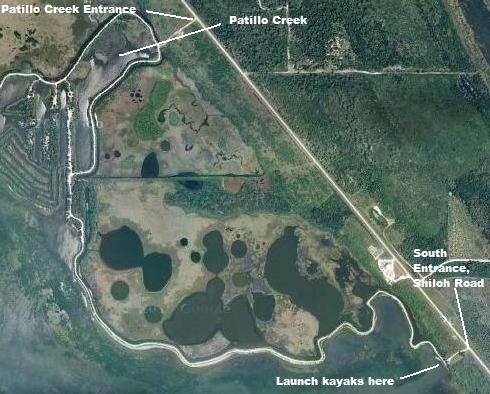 The
Southernmost entrance to Shiloh
Marsh Road is at Live Oak,
about a mile North of Haulover Canal on
the left. This first section is about
2.4 miles and will take you out into the
Indian River Lagoon adjacient to a large
impoundment and ultimately lead you to
Patillo Creek and Patillo Creek Road. It
will expose you to about 1 and 1/2 miles
of lagoon shoreline to fish for reds and
seatrout and ultimately lead you to the
Patillo Creek area, which is known to
hold trout, reds, snook, and tarpon. You
can then exit at Patillo Creek Road or
continue north along Shiloh The
Southernmost entrance to Shiloh
Marsh Road is at Live Oak,
about a mile North of Haulover Canal on
the left. This first section is about
2.4 miles and will take you out into the
Indian River Lagoon adjacient to a large
impoundment and ultimately lead you to
Patillo Creek and Patillo Creek Road. It
will expose you to about 1 and 1/2 miles
of lagoon shoreline to fish for reds and
seatrout and ultimately lead you to the
Patillo Creek area, which is known to
hold trout, reds, snook, and tarpon. You
can then exit at Patillo Creek Road or
continue north along Shiloh
GPS N 28 45.113 W 80 46.274
Google Satellite Image
|
|
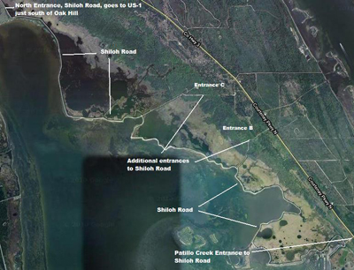 Heading North from Live Oak on SR-3,
Patillo Creek Road is the next
entrance to Shiloh Marsh Road and goes from
the Patillo Creek Area and winds along the
dike impoundment out into the lagoon itself
while circling around several coves before
making its way back to SR-3. There are about
3 1/2 miles of shore fishing and kayak/canoe
launching opportunities along this road and
while I haven't fished this road yet some of
the coves and the area near the outwardmost
tip look very inviting, especially the
islands off of the tip by kayak.
Heading North from Live Oak on SR-3,
Patillo Creek Road is the next
entrance to Shiloh Marsh Road and goes from
the Patillo Creek Area and winds along the
dike impoundment out into the lagoon itself
while circling around several coves before
making its way back to SR-3. There are about
3 1/2 miles of shore fishing and kayak/canoe
launching opportunities along this road and
while I haven't fished this road yet some of
the coves and the area near the outwardmost
tip look very inviting, especially the
islands off of the tip by kayak.
Patillo Creek Entrance to Shiloh Road GPS
N 28 45.851 W 80 46.977
Patillo Creek Entrance to Shiloh Road Google
Satellite Image Entrance B to
Shiloh Road GPS N 28 46.932 W 80 47.907
Entrance B to Shiloh Road Google Satellite
Image Entrance C to Shiloh Road
GPS N 28 47.404 W 80 48.295
Entrance C to Shiloh Road Google Satellite
Image
Volusia County US-1 Entrance to Shiloh Road
GPS N 28 49.674 W 80 51.060
Volusia County US-1 Entrance to Shiloh Road
Google Satellite Image
|
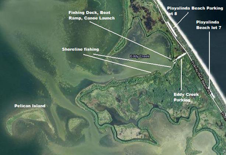 Eddy
Creek has a boat ramp and
offers paddling access to the
southernmost reaches of the Mosquito
Lagoon. To get there, take SR-406 to
SR-402 (Thats where the road veers to
the right near the turnoff to get to
Black Point Wildlife Drive.) Go past the
Refuge Visitors Center and continue to
the intersection of SR-402 and SR-3. Go
straight ahead at the light and follow
the road through the pay station for
Canaveral National Seashore and all the
way to the beach access road. Heading
north, you will find the parking area
for Eddy Creek on the left side of the
road just after beach parking area # 7. Eddy
Creek has a boat ramp and
offers paddling access to the
southernmost reaches of the Mosquito
Lagoon. To get there, take SR-406 to
SR-402 (Thats where the road veers to
the right near the turnoff to get to
Black Point Wildlife Drive.) Go past the
Refuge Visitors Center and continue to
the intersection of SR-402 and SR-3. Go
straight ahead at the light and follow
the road through the pay station for
Canaveral National Seashore and all the
way to the beach access road. Heading
north, you will find the parking area
for Eddy Creek on the left side of the
road just after beach parking area # 7.
There is a dock for fishing at the park
as well as some easily walked shoreline
along the southern edge of the cove.
Fish here with live shrimp for reds,
trout, and a variety oif other species
such as mangrove snapper, sheepshead,
drum etc.
If paddling, fish both in the cove and
out of it on the lagoon. Outside the
cove you will see Pelican Island to the
southwest as well as another smaller
island almost due south. Fish the flats
around both islands for reds and trout.
West of the larger island, pelican, you
will find a deeper area that can hold
reds, trout, early spring tarpon and a
variety of other species.
GPS N 28 40.541 W 80 38.884
Google Satellite Image
|
|
|
|
|