|
|
|
Surfing the Space Coast |
Click
 below to see surf cam for that location
 |
|
Jump Menu
{North Area; Includes
Playalinda Beach @ Canaveral Nationa
Seashore}
{Central Area; Includes
Cocoa Beach, Patrick Air Force Base,
Satellite Beach, Indian Harbour Beach}
{South Area; Includes
Indialantic, Melbourne Beach, Spanish House,
Long Point, Sebastian Inlet}
Florida Swell Forecast and Florida Wave
Model
Noaa Buoy Data >>|
20 Mile |
120 Mile |
St Augustine
Weather / Tides Forcast
|
|
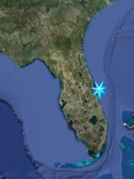
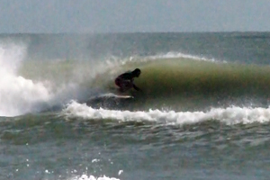 The
Space Coast of East Central Florida
is a mecca for East Coast Surfing and has
produced some of the top surfing talent in
the world, including 11 (and counting) time
world champion Kelly Slater of Cocoa Beach,
and surfing twins C.J. and Damien Hobgood of
Satellite Beach. Many sections of the Space
Coast Beaches are great for learning the
sport, particularly around the Cocoa Beach
Area, while others are better left to more
experienced surfers such as first peak at
Sebastian Inlet and Monster Hole, about 1/4
of a mile offshore of the South Jetty at
Sebastian Inlet. The
Space Coast of East Central Florida
is a mecca for East Coast Surfing and has
produced some of the top surfing talent in
the world, including 11 (and counting) time
world champion Kelly Slater of Cocoa Beach,
and surfing twins C.J. and Damien Hobgood of
Satellite Beach. Many sections of the Space
Coast Beaches are great for learning the
sport, particularly around the Cocoa Beach
Area, while others are better left to more
experienced surfers such as first peak at
Sebastian Inlet and Monster Hole, about 1/4
of a mile offshore of the South Jetty at
Sebastian Inlet.
|
|
|
|
Jump Menu
{North Area; Includes
Playalinda Beach @ Canaveral Nationa
Seashore}
{Central Area; Includes
Cocoa Beach, Patrick Air Force Base,
Satellite Beach, Indian Harbour Beach}
{South Area; Includes
Indialantic, Melbourne Beach, Spanish House,
Long Point, Sebastian Inlet}
Weather / Tides Forcast
Top of Page
|
Playalinda Beach,
Canaveral National Seashore.
Playalinda means "pretty beach" in Spanish,
and Playalinda Beach east of Titusville
lives up to the name. Its part of Canaveral
National Seashore's 26 miles of undeveloped
beach stretching from New Smryna Beach in
the North to the massive Space Shuttle
Launch Pads to the South, so when surfing
here bring everything you need for the day,
there are no shops for drinks, food, etc.
Playalinda is a beach break, sand bottom,
with rights and lefts and being North of the
actual Cape of Cape Canaveral, the beach
faces E-NE so it will go off better on a
northerly swell. It is a beach for all
experience levels and during the week will
be relatively empty and on weekends crowds
are usually moderate.
GPS N 28 39.108 W 80 37.793
|
Magic Seaweed Surf Report
PlayalindaBeach.net
Playalinda Beach Tides
Google Satellite Image |
|
|
|
Jump Menu
{North Area; Includes
Playalinda Beach @ Canaveral Nationa
Seashore}
{Central Area; Includes
Cocoa Beach, Patrick Air Force Base,
Satellite Beach, Indian Harbour Beach}
{South Area; Includes
Indialantic, Melbourne Beach, Spanish House,
Long Point, Sebastian Inlet}
Weather / Tides Forcast
Top of Page
|
|
Cocoa Beach Pier;
401 Meade Avenue, Cocoa Beach,
FL 32931
(1/2 Mile North of 520, off A1A)
Phone: (321) 783-7549
Built in 1962 the Cocoa beach Pier has
become a historical landmark in these parts.
In addition to the 800 ft fishing pier,
there are 5 restaurants, 4 bars, and gift
shops.The pier also offers fishing equipment
rentals, bait sales, beach rentals, fresh
water showers, regulation beach volleyball
courts, lifeguards year round. Annual events
include beach concerts and surf festivals
throughout the year, including the National
Kidney Foundation's Pro Am Easter Surfing
Festival. The Beach Boys, UB40, Ali
Campbell, Julian Marley, Maxi Priest and
many others are some of the performers that
have played here. Expect to pay for parking
nearby.
Easy wave to surf suitable for all levels,
beach break with lefts and rights, and a
sand bottom. Know that this beach will
almost always be pretty crowded. There are
several surf schools in the area.
GPS N 28 22.066 W 80 36.121
Cocoa Beach Surf Report
Google Satellite Image
|
| |
|
Lori Wilson Park
1500 N Atlantic Avenue, Cocoa Beach
FROM SR-520 go south 1.4 miles on SR-A1A
Open after sunrise until dusk, except for
scheduled use.
ADA ACCESSIBLE: Parking, Restrooms,
Pavilions, Playground, Boardwalk, 4 Dune
Crossovers, Nature Center, Nature Boardwalk,
Paved Walkways.
Sandy beach break with lefts and rights,
with waves of average power, suitable for
all surfers. Starts to go off at just under
3 ft. Can be crowded on weekends.
GPS N 28 20.227 W 80 36.470
Google Satellite Image
|
| |
|
13th Street,
Cocoa Beach
East end of 13th Street in Cocoa Beach
Sandy beach break with lefts and rights,
with waves of average power, suitable for
all surfers. Starts to go off at just under
3 ft. Can be crowded on weekends. Best at
low tide.
GPS N 28 17.710 W 80 36.468
Google Satellite
Image
|
| |
|
Tables,
Patrick Air Force Base
Patrick Air Force Base South of Cocoa Beach
This will be the first public parking area
south of Cocoa Beach on the oceanside of A1A
across from the northernmost gate into the
secure portion of the base.
This is a sandbar break which peaks nicely
during any significant swell. Goes left and
right with a sandy bottom and average power
waves. Suitable for all surfers, can be
crowded on weekends. Best at mid to high
tides.
GPS N 28 16.007 W 80 36.304
Patrick Air Force Base Tides
Google Satellite Image
|
| |
"O" Club Beach, Patrick Air Force Base
This used to be the site of the
Patrick Air Force Base Officer's Club until
the place caught on fire and burned to the
ground, hence the name, "O
Club Beach". If you are civilian, park in
the southern section of the lot.
This is a sandbar break with a sand bottom,
lefts and rights, and average power waves
suitable for all levels of surfers. Best at
mid to high tides.
GPS N 28 15.443 W 80 36.244
Google Satellite Image |
| |
2nd Light, Patrick Air Force Base
Known as Florida's Wave Magnet this
is a very consistent beach break, with a
sand bottom, rights and lefts and breaks
even on small waves when other spots are
flat. Good beach for all levels. When a
hurricane swell comes in it produces nice
barrels which draws some of the best surfers
around.
GPS N 28 15.147 W 80 36.203
Google Satellite Image |
| |
Hangers, Patrick Air Force Base
When the waves are small, this is a
great longboard spot. When a swell comes in,
it's best for more experienced surfers.
Known to produce some nice barrels. Sandy
beach break with some coquina rocks, lefts
and rights. Usually less crowded than 2nd
Light.
GPS N 28 14.562 W 80 36.105
Google Satellite Image |
| |
RC's Satellite Beach
This is a reef break that during a
swell can produce fast, powerful, hollow
waves suitable for more experienced surfers.
Be aware of rip currents during swells, and
the coquina rocks that form the reef. One of
the better breaks in the Satellite Beach
area.
GPS N 28 10.684 W 80 35.389
Magic Seaweed Satellite Beach Surf Report
Google Satellite Image |
| |
Peg Legs, Satellite Beach
Located at the ocean end of DeSoto
Parkway in Satellite Beach this is a reef
break which produces lefts and rights and is
suitable for all levels. Can be really nice
outside when a swell is on.
GPS N 28 09.886 W 80 35.207
Google Satellite Image
|
| |
|
Irene H. Canova Park Indian Harbour
Beach
2289 Highway A1A, Indian Harbour Beach
Parks Referendum Project
FROM US Hwy 1 go east 3.3 miles across the
Eau Gallie Cswy (SR-518), turn left on
SR-A1A and go 0.1 miles to the park.
Park open after 7:00 a.m. until dark.
This is a beach break with rights and lefts,
and produces fairly steep walls and hollow
waves. The bottom is sand with some coquina
rock. This is also a very popular spot so
expect some local attitudes. Best for
experienced surfers.
GPS N 28 08.322 W 80 34.827
Google Satellite Image
|
| |
|
|
Indialantic Boardwalk;
Located at the end of State Road
192 or Melbourne Causeway.
This is a sandy beach break with waves of
average power, rights and lefts, and
suitable for all levels of surfer.
GPS N 28 05.497 W 80 33.949
Google Satellite Image |
| |
Ocean Avenue;
Located at the end of Ocean Avenue
in Melbourne Beach.
This is a sandbar break with average to good
waves during a swell, rights and lefts, and
generally suitable for all surfers.
GPS N 28 04.104 W 80 33.407
Melbourne Beach Surf Report
Google Satellite Image |
| |
Spessard Holland North Beach, Melbourne
Beach
2525 Highway A1A, Melbourne Beach
FROM US-192 (Melbourne Cswy), go south on
Miramir Ave/SR-A1A 1.0 miles to the
intersection with Ocean Blvd and Oak St. Go
left around the curve onto Atlantic Ave and
continue 2 miles. The park is on the left.
Open after 7:00 a.m. until dark, except for
scheduled use.
ADA ACCESSIBLE: Parking, Restrooms.
This is a fairly consistent sandy beach
break with rights and lefts, waves of
average power, and generally suitable for
surfers of all levels.
GPS N 28 03.291 W 80 33.064
Google Satellite Image |
| |
Long Point;
Near the entrance to Longpoint Park
about 2 miles north of Sebastian Inlet. Park
at the Longpoint Food Mart on the west side
of A1A and walk across the highway to the
beach. There is a small sand parking area
but the sand is fairly soft and it's easy to
get a car stuck.
This is a sand bar break with some deep
water between the offshore sandbar and the
beach. Popular with longboarders, with lefts
and rights and some nice hollow waves.
Suitable for all surfers.
GPS N 27 52.976 W 80 27.542
Google Satellite Image |
| |
|
Spanish House
Located across A1A from the access road to
the Sebastian Inlet Marina, this sandbar
break is one of the best spots on the east
coast of Florida, and one of the most
popular, in spite of the drive, as it is
fairly distant from most major cities along
the Space Coast. It is a bit off the shore
with some deep water between the bar and the
shore. During normal conditions it produces
consistent waves of average power with lefts
and rights and is suitable for all surfers.
When it gets big, the waves are fast,
powerful, and hollow, and draws surfers from
around the state, ie, it gets crowded and is
best left to experienced surfers.
GPS N 27 52.570 W 80 27.338
Spanish House Surf Report
Google Satellite Image
|
| |
Sebastain Inlet State Park, North Jetty
When first peak goes off, this spot produces
some of the fastest most powerful waves
along the East Coast. It is a jetty break
and the energy from the incoming wave
bounces off the north jetty and forms a
raised peak in the wave just north of the
jetty. Obviously the direction is right
only. The wave is fast, powerful, and
hollow, which is why several tournaments are
held here each year. On weekends this spot
can be ultra crowded. Best for experienced
surfers who can hold their own in the
lineup.
GPS N 27 51.733 W 80 26.781
Sebastian Inlet Surf Report
Google Satellite Image |
| |
Monster Hole, Sebastian Inlet State Park
Monster hole is a sandbar and reef
structure about 1/4 mile off of the tip of
the south jetty at Sebastian Inlet, with
deep water between the bar and the shore.
During the normal relatively flat days of
Summer you can't even tell it's there. It
takes a swell of about 3-5 feet to set it
off. When it does break, it produces fast,
powerful, and hollow lefts that peel off for
100 yards or more. The place is also known
for sightings of large sharks. Not for
beginners. Access is by boat or a long
paddle from shore. Some surfers have been
known to jump from the north jetty and
paddle across the inlet. When surfs not up
the place is known as a dive spot.
GPS N 27 51.624 W 80 26.426
Google Satellite Image |
|
|
|
|